
Heimsóknir
Flettingar
- Í dag (4.7.): 0
- Sl. sólarhring:
- Sl. viku: 1
- Frá upphafi: 0
Annað
- Innlit í dag: 0
- Innlit sl. viku: 1
- Gestir í dag: 0
- IP-tölur í dag: 0
Uppfært á 3 mín. fresti.
Skýringar
Færsluflokkar
Eldri færslur
Balls of Hyaloclastite
17.2.2010 | 18:52
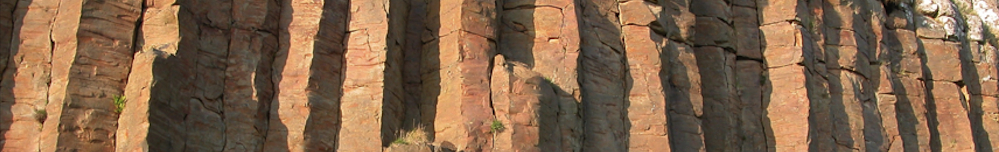
 It is a bit peculiar that the name of the largest eruption in Iceland, in fact the largest lava eruption in history, is taken from a mountain that did not erupt. I am referring to the hyaloclastite mountain Laki in southern Iceland. Laki mountain was split in two in the great eruption of 1783 when a 25 km long fissure rifted the terrain and created Eldhraun, the Fire Lava. The rifting produced two prominent faults that flank the fissure, where we can see well the interior of the Laki mountain. The hyalocastite was formed during subglacial eruptions in the last ice age, or more than ten thousand years ago.
  Anyone who enters into the canyon made by the fault line is amazed to see that the hyaloclastite rock is full of spherical structures about the size of a football or a man´s head. Many tourists come here, and Kári Kristjánsson, the ranger of the Lakagígar fisure, is not enthusiastic about how tourists treat these important geological artefacts. Some tourists arrange the balls into piles, like soldiers stacked cannon balls in centuries past, and others use the balls to play bowling games. But he is least impressed when tourists stuff them in their backpacks and attempt to carry the balls off. As you can see from the photograph above, the balls are inside the hyalocalstite formation, but they weather out and are scattered on the ground below. The balls are a bit harder than the hyaloclastite and wether more slowly, but in other respects they are identical to the hyaloclastite, composed of glass particles, volcanic ash and small fragments of basalt, all cemented together into a hard rock.
 Hyaloclastite, called móberg in Icelandic, is in fact the most amazing rock of Iceland and should be the national rock. It is much more common in Iceland than anywehre else on Earth, and the hyaloclastite mountains are an important feature of the Icelandic landscape. This rock does not get enough respect in Iceland, and it was in fact not until the eruption of the island of Surtsey in 1963 that scientists figured out fully how this rock is formed. We now know that hyaloclastite is hardened volcanic ash or tephra, which has become cemented into rock.
  In most cases the volcanic ash has the chemistry of basalt, and is formed when basalic magma comes in contact with water, either below a glacier, in the ocean or in a lake. But how are the mysterious hyaloclastite cannon balls formed?The first to describe them in print was the geologist Jón Jónsson in 1987. He wrote: “The hyaloclastite balls are simply tephra balls, which have formed when wet or suitably moist volcanic ash layer rolled upp.” His idea was that the balls were syndepositional, or formed at the same time that the deposit formed.
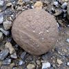
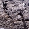
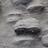
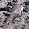
  I disagree with that interpretation.The best and largest occurrence of hyaloclastite balls that I have seen occur in the western part of Kerlingarfjall mountain on Snæfellsnes in western Iceland. The hyaloclastite cliffs here are several tens of meters in height, and they are full of balls that are about 30 cm in diameter. The photo above shows the cliff, but in right light conditions, especially at dusk, this is the most ghostly place I have ever visited, when the hundreds of balls stick out of the wall, like the heads of human corpses that have been stacked up and turned to stone.
  Hyaloclastite balls of all sizes are common in the Kerlingarfjall mountain, and also in Valabjörg to the east.When we look more closely, we can see that there is a faint stratification in the hyaloclastite of Kerlingarfjall, and that the layering cuts right through some of the balls, as the photos show. Layering is of course produced mainly during the eruption and is caused when explosions produce volcanic ash or tephra of varying grain size. But if the stratification cuts across the balls, then the hyaloclastite balls must clearly have formed AFTER the layering, and the balls are herefore a postdepositional feature, formed after the eruption. They are most likely analogous to concretions that form in sedimentary rocks.
  They are created when a process of crystallization begins from a nucleus and then radiates outward to form a spherical structure. Thus it is the cement within the balls that gives them the spherical shape.
The Volcanic Photo of the Year 2009
17.2.2010 | 01:55
 The greatest volcanic photograph of the year 2009 was taken of the eruption of Sarychev volcano in the Kuril Islands on the 12. June from a space craft. The Kuril Islands are one of the most remote parts of Russia. They are 56 islands which form a 1300 km long chain that stretches south from the Kamchatka peninsula, in easternmost Russia, all the way south to Japan. Russia occupied the islands in World War II and refused to give them up, but the native inhabitants were Japanese.
  The islands have formed above a great subduction zone, where the Pacific plate subducts to the northwest below the Eurasian plate, at a rate of about 9 cm per year. The international space station was at an altitude of 354 km over the Pacific on the 12. June when the astornauts witnessed the enormous volcanic plume shooting up into the atmosphere, and punching a hole up through the cloud cover. The hole was probably formed by the pressure wave of the volcanic explosion. In the center there is a high and brown colored plume of ash from the crater below. Note the snow-white cloud which forms a cap on top of the eruption plume. This is probably a part of the water-rich cloud layer which the eruption plume lifted high up into the cooler atmosphere, where the cloud condensed. A lot of things were also taking place down on Earth at the same time as the photo shows. Grey and brown pyroclastic flows are streaming along the ground from the volcano, but they can be up to 500 degrees Centigrade in temperature and move at speeds of up to 200 km per hour.
  The island of Matua is not inhabited but a few days later the Russian volcanologists paid a visit and studied the pyroclastic flows, which had entered the sea. The Sarychev eruption in 2009 transformed the island of Matua, as is shown on the photos from a NASA satellite and thermal scanner. The first photo is of Matua from 26. May 2007, and the lower photo is of the island after the eruption, from 30. June 2009. The vegetation is shown in a red color, water is darkblue and clouds, steam and ice are whie in the photo. Volcanic ash and lavas are grey and darkbrown in the photos. It is clear from the lower photo that pyroclastic flows have covered all of the north part of the island and destroyed all vegetation, but some vegetation sirvives in the southern part.
 Loomweights from Iceland and Crete
17.2.2010 | 01:07
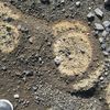
 In the spring of 2009 I was visiting my neighbor in Stykkishólmur, Einar. He is a great rock collector, and most of the big rocks are outside, in the garden, perhaps at his wife´s request. I immediately spotted a basalti rock which was puncured through by narrow pipe-like holes, as if it had ben drilled. “Where did you find it?” I asked. “It is from the seacliffs of Mígandi waterfall at the farm of Kljá” he said. Mígandi in Icelandic means the pisser. Two strange names: Mígandi and Kljá. It reminded me of the story of my grandfather, Oddur Valentínusson, the harbor pilot of Stykkishólmur for many years. It was in the summer of 1941, which was so dry that al the wells in the village dired up. My grandfather took a huge sail and spread it over the deck of his boat Gola, and sailed it up undr the waterfall of Mígandi, where the waterfall plunges directly into the sea. When the boat was nearly full of water, he put the engine in reverse and motored back home with a boatful of fresh water for the home. The next day Einar and I hiked to the waterfall to study the rock formation where the rocks with the holes came from. I saw that this was pillow lava, or lava that has formed by flowing into the ocean. The photo to the left shows one of the pillows.
  Under these conditions, the seawater boils below the hot lava flow and creates seam which expands and breaks a path up through the molten lava flow and leaves behind narrow pipes in the lava as it solidifies. The first thing that came to mind was loomweights when I saw these stones, which were all perforated with long pipe-like holes. The whole beach was littered with them. Later I found out that this lava had flowed from Hafrafell volcano on Snæfellsnes during the last interglacial period, probably about one hundred years ago. But what are loomweights? They are stones that are used to weigh down or stretch the loom during weaving. In Icelandic they are kalled kljásteinar. But wait a minute! That is the name of the farm above the locality where we had just found these strange and beautiful rocks with the pipes! I was familiar with loomweights through my work in Crete in the Aegean Sea. Working in the Bronze age coastal deposits of Crete in 2007 and 2008, I discovered several loomweights that had ben caught in the tsunami or tidal wave that was generated during the great eruption of Santorini.
  They are shown in the photo above and they are exhibited at the Volcano Museum in Stykkishólmur, Iceland. The Icelandic name for loomweights is kljásteianr, and Kljá is the name of the farm wehre we found these stones. Is the farm´s name derived from the abundance of readymade loomweights at the beach? I think so. Such stones are rare in Iceland and this must have been a special locality in the middle ages.
 Nýjustu myndir
Af mbl.is
Erlent
- Skæðir gróðureldar í Kaliforníu
- Rússland viðurkennir yfirráð Talíbana fyrst landa
- Fjórir létust í skotárás fyrir utan næturklúbb
- Ölið fæst ekki ódýrt á HM félagsliða
- Stóra, fallega frumvarpið komið á borð forsetans
- Árás í hraðlest í Þýskalandi
- Neitað um bætur – Ættleidd til Danmerkur sem börn
- Stunguárás við verslunarmiðstöð í Finnlandi
Fólk
- „Ég ætla að fá fullnægingu!“
- Innlyksa í alls konar aðstæðum
- Sér eftir að hafa fengið sér Tyrklandstennur
- Leikarinn Michael Madsen er látinn
- Vonar að Íslandsvinurinn verði náðaður
- Orlando Bloom einmana eftir sambandsslitin
- Ósátt við að Combs var sýknaður af ákæru um mansal
- Timothée og Kylie taka sambandið á næsta stig